The weather – basic principles
Weather, is the state of the atmosphere in a certain place, for a short period of time.
The energy received by the Earth from the Sun is the main cause of weather phenomena.
In order to easily understand the operation of weather phenomena, we should refer to the following 3 basics:
1. Warm Air Rises
Warm air is lighter and rises, while cool air is heavier and descends.
2. Warm Air Holds More Moisture
Warm air holds more water vapor than cold air, making summers humid.
3. Coriolis Force Spins Air and Water
The Earth's rotation curves air and water movement:
- clockwise in the North
- counterclockwise in the South
- no effect at the Equator
The combination of these three principles drives the complexity of weather phenomena.
Rising warm air, its capacity to hold moisture, and the Coriolis effect interact with factors like air friction, geographic obstacles, and temperature gradients, creating the dynamic and ever-changing patterns we observe.
Atmosphere
The atmosphere, a mixture of gases, surrounds our planet at a height of up to 1,000 km, providing protection from:
- the sun's ultraviolet radiation
- meteors
- extreme temperature fluctuations between day and night (greenhouse effect).
Weather phenomena (clouds and storms) occur in the so-called "Troposphere", at a height of 0-18 km from the surface of the earth.
That's why airplanes choose to fly in the "safety" of the stratosphere, the zone above the troposphere.
The Troposphere is the densest layer of the atmosphere (it gathers about 80% of the total material of the atmosphere) and, among other things, it is rich in water vapor and particles (dust, pollen, salt).
Heat and Humidity: Weather's Key Players
Weather phenomena are driven by two key elements: HEAT and HUMIDITY. The sun warms the ground, causing water from seas and lakes to evaporate, adding moisture to the atmosphere. This interaction between heat and humidity lays the foundation for the dynamic processes shaping our weather:
1. Warm Air Masses
Air warmed by the sun becomes lighter, absorbing moisture from the surface below.
This creates conditions favorable for atmospheric movement, with moist air playing a central role in weather formation.
2. Drop in Atmospheric Pressure
As air moves upward or is displaced by warming processes, a zone of low atmospheric pressure forms near the surface.
These low-pressure systems are crucial in setting weather patterns into motion, often bringing unsettled conditions.
3. Creation of Clouds
At higher altitudes, cooler conditions cause the moisture in the air to condense.
This condensation, assisted by particles like dust and salt, forms tiny water droplets that cluster together as clouds.
These clouds are an indicator of upcoming weather changes.
4. Increase of Atmospheric Pressure
Cold air from higher altitudes descends, becoming denser and creating zones of high atmospheric pressure.
These areas are often associated with clear skies and calm weather, providing a period of stability.
Atmospheric pressure
Atmospheric pressure is measured with barometers.
The standard unit is the hectopascal (hPa), though meteorological forecasts often use millibar (mbar) - both are equivalent.
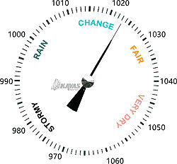
At sea level, pressure is typically 1013 mbar, but it drops significantly with altitude, reaching just 300 mbar at Everest's summit.
A barometer is an essential tool, especially for sea voyages.
- Low pressure or a sudden drop signals bad weather.
- High pressure indicates good weather.
Shaping Climate and Weather
Since sunshine plays such an important role in shaping the weather, the climate of a place will include parameters such as:
- Latitude of the place (distance from the Equator), since the places closest to the Equator heat up more.
- Morphology of the place. Water surfaces produce more moisture than land.
Also, the ground covered by trees is heated more difficult by the sun.
The atmospheric pressure of a place is not constant and changes continuously because:
- Neighboring places interact, due to the existence of a difference in atmospheric pressures.
- Areas of high pressure seek relief towards areas of low pressure.
The Wind
Air masses at high pressure (H) tend to move towards areas of low pressure (L).
This movement creates the wind.
To describe the wind, we use 2 measurements:
- Intensity. The units commonly used are "Bft" or "knots".
- Origin. The wind is characterized by where it comes from.
Thus, when it comes from the North, it is called "northern".
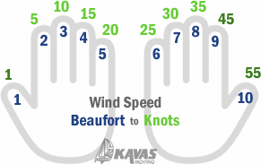
Air intensity reports come in Bft or Knots.
If you are familiar with only one of the two units, you may have difficulty using the weather reports with ease, so we give you the following practical way to convert:
Beaufort-Knots Conversion (Both Ways)
Extend your palms, paying attention to the 10 fingers:
Isobar lines
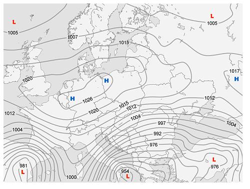
If (at a specific time) we mark on a map the points of the same atmospheric pressure of a large geographical area, and we join them, we will have the formation of curves, which we call isobar lines (see the following figure)
The denser the isobar lines, the stronger the winds in the area.
Barometric Systems
Air masses are areas that contain air of similar heat and humidity, which, as mentioned above, are the main causes of weather phenomena.
The air masses move, creating the barometric systems:
- Warm rising air masses ( Low pressure systems L or cyclones ), create clouds and unsettled weather.
- The cold air masses descending ( High pressure systems H, or anticyclones ), dispel the clouds and contribute to the summer.
- The "fronts" which describe the horizontal movement of the boundary of two gas masses of different temperature.
The Coriolis effect
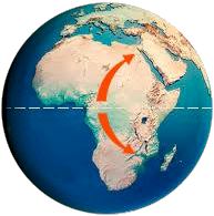
The Coriolis effect, caused by the Earth's rotation, influences the movement of air masses, creating distinct swirling patterns.
Descending cold air is deflected to the right in the Northern Hemisphere, resulting in a clockwise rotation, known as an anticyclone.
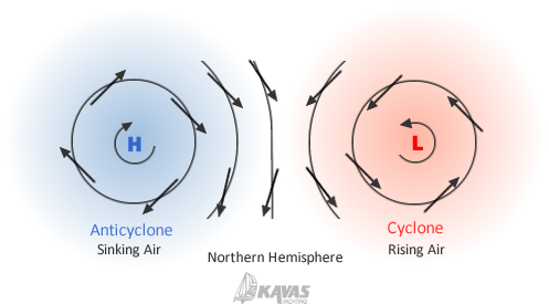
Conversely, rising warm air is also deflected, but in the opposite direction, creating counterclockwise rotation, or a cyclone. When these opposing systems interact, the difference in pressure and temperature between them intensifies wind patterns, often leading to stronger winds and more dynamic weather conditions.
Air Mass Origins
Air masses are characterized by their origin, in 4 major categories:
- Warm: of tropical origin
- Cold: of polar origin
- Liquid: origin from large marine areas.
- Dry: origin from continental areas
The change of weather in a geographical place will be determined by the origin of the air mass that will "visit" it.
Fronts
A front is the boundary between two gas masses of different temperatures and is characterized as "warm" or "cold" according to the temperature of the gas mass that moves faster.
The meeting of two gas masses of different temperatures, is of great interest.
Warm Front
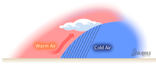
The warm air mass moves at a higher speed than the cold one, which precedes it and is lighter, climbs and "slides" over it.
Warm air (always richer in water vapor than cold air), forms an extensive cloud system ahead of the location of the front, which is often stormy!

A warm front is symbolized on weather maps as a red line with red semicircles.
Cold front
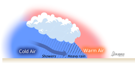
Unlike warm fronts, cold fronts show no signs of approaching!
The cold mass forcefully penetrates below the warm one, forcing it to rise sharply to higher layers.
As the cold front passes, there is an increase in weather phenomena: gusty winds, a sharp drop in temperature, heavy rain (or even hail) and lightning.

The cold front is symbolized on weather maps as a blue line with blue triangles.
Local Winds
Sea breeze
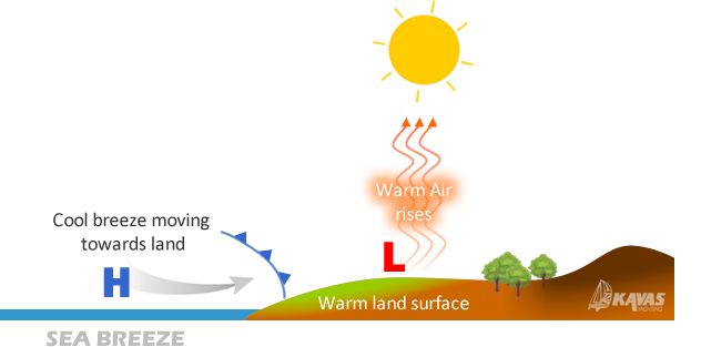
We will have noticed in the summer, that when approaching the coasts we receive a cool breeze from the sea side.
It is the sea breeze.
This happens when the hot ground heats up and sends the air up, "pumping" in this way the much cooler sea air.
Land breeze
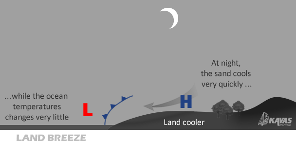
The opposite happens when the sun goes down.
The temperature difference of the cold air of the land with the not so cold surface of the sea, creates the gentle breeze towards the sea.
The land breeze is weaker than the daytime sea breeze because the land-sea temperature difference is not as great.
Meltemi
Barometric systems create local, often strong winds, the most prevailing of which we have given names.
The well-known winds of the Mediterranean are the (Eastern) Levante of Spain, the NW Mistral of France, the NE Bora of the Balkans and the Greek Meltemi, which appears every summer in the Aegean, with the rising of the Sun and fades with the setting.
The Meltemi is created by the meeting of a High pressure system H (anticyclone) of the Balkans and a Low pressure system L (cyclone) of Turkey, producing strong northerly winds, from June to September.
With our face turned to the wind, we always have a High pressure system H on our left and a Low pressure system L, on our right.
Global wind circulation
Air movement between the equator and poles drives global weather patterns, shaped by temperature differences and the Earth's rotation.
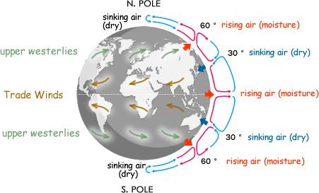
The warm (rising) equatorial air will move towards the poles, while the cold polar air is pushed towards the equator.
Air movement would be "directly" north or south if the earth did not rotate.
1. Desert Formation at 30° Latitude
The warm air masses of the Equator begin to rise while at the same time drifting to the east due to the rotation of the earth.
At a height of 10-15 km, they turn towards the poles, and at a latitude of 30° they begin to descend as cold and dry air masses.
2. Forest Development at 60° Latitude
The course of the gas masses towards the poles is stopped again at the latitude of 60°, when as warm (and moist) gas masses, they rise.
This rising moist air supports the development of lush vegetation and creates temperate and boreal forests, such as those found in the northern parts of Europe and North America.
Like the equatorial masses, one part continues the course towards the poles and the rest turns towards the equator, where, at 30°, they sink again.
Trade winds
At a latitude of 30°, cold air masses originating from the Equator, together with those of latitude 60° (north or sount), descend.
This descending cold and dry air mass is turned by the Coriolis force, towards the west (clockwise in the Northern Hemisphere – counterclockwise in the Southern Hemisphere).
These are the "trade winds", which blow almost all year round and move between 15° and 30° latitude (northern and southern hemisphere).
They are of mild intensity (3-4 Bft) and sometimes they can cause a hurricane.
Trade winds greatly aided trade with sailing merchant ships, such as across the Atlantic.
These winds, which come from dry air masses, are also responsible for the existence of the Sahara, Arabian, Kalahari and Australian deserts.
In these deserts, where there is no water vapor to trap the temperature, extreme day-night temperature differences are observed.
Westerlies
A similar phenomenon is observed at the latitude of 60°, where gas masses from the subtropical zones and currents from the polar zones meet.
This time the Coriolis force gives birth to the "westerlies" giving them direction to the east.
These winds move between 60° and 30° latitude, while transporting moist air masses, creating temperate climate conditions (rainfall, cool summers, mild winters).
Westerly winds sustain the forests of Brazil, Central Africa, and Central Asia (monsoons).
Jet streams
It is worth noting the existence of 2 strong jet streams, one in each hemisphere, at heights from 8 km to 15 km, moving at speeds exceeding 400 km/h with eastward direction, one at the latitude of 60° and the other at 30° latitude, caused by the extreme temperature differences.
The global circulation of winds is explained in great detail by ecoweather.com.
Weather forecast
The weather forecast concerns the study of atmospheric data and the physical atmosphere of specific geographical areas (cubic areas of a few km).
When we want to be informed about the weather, using applications such as "Windy", we start with a general model that will inform us long term and then go with a local one for short term updates.
The smaller the side of the cube, the greater the prediction accuracy but with a more limited depth of time:
| MODEL | CUBIC AREA | FORECAST DEPTH |
|---|---|---|
| GFS (NOAA) | 22km | 10-15 days |
| ECMFW (EU) | 9km | 5 days |
| ICON-EU | 7km | 5 days |
| NEMS local | 4km | 2 days |
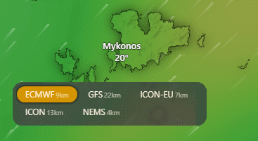
Check out these interesting sources for your weather forecast in the Greek seas.
☀ Poseidon
☀ Windy
☀ Windguru
Note: Most forecasts give the average value of the expected wind.
The rule says that we add 50% to count for the gusts!
Practical Weather Forecast by studying the clouds

☀ An obvious sign that the weather will be bad is in the very sparse Cirrus clouds, which form in very high layers, heralding the arrival of a warm front (usually).
⛈ If the Cirrus thickens more (Cirrostratus), we will see a wreath surrounding the sun or the moon (halo), so the signs of a warm front (bad weather) are amplified.
☁ As the front approaches, the clouds lower and thicken even more (Altostratus), until the sun leaves no shadows on the objects.
🌧 Finally, the clouds release rain (Nimbostratus) for the next 4 hours.
☼ Cumulus: They are the white clouds that resemble cotton. These are not a cause for concern and are a sign of summer weather.
🌩 Cumuloninbus: These clouds are of much interest because they threaten the safety of sailing. They grow vertically, starting almost from the surface of the sea, covering the entire troposphere. Visually, they are presented as a very tall stack of Cumulus. Inside this large vertical stack, there are strong up and down currents, thinder, lightning and hail.
Understanding natural signs like lightning, cloud color, and bird behavior can help predict approaching storms. Combine these with barometer readings to stay prepared and safe at sea.
Weather Tips
- Weather phenomena "travel" from West to East.
- If we see lightning (west), we count the seconds until we hear the thunder and then divide this number by 3.
The result gives us the distance of bad weather from where we are.
eg If "Lightning to Thunder" needs 6 sec, bad weather is 6/3 = 2 km away. - Clouds are a threat when they are dark in color, not white.
- When bad weather approaches, seagulls seek shelter.
Land birds, fly low.
When you see this sign, confirm the atmospheric pressure drop in your barometer.

